Files, Formats, Frequencies
Environment Variables
You need three environment variables to run this code: REFL_CODE, ORBITS, and EXE. If you are using the jupyter notebooks or the docker, they are defined for you. If you are working with pypi or github install, you must define them EVERY TIME YOU USE THE CODE. This is most easily done by setting them in your setup script, which on my machine is called .bashrc.
GPS/GNSS Data Formats
Input observation formats: the code only recognizes RINEX 2.11, RINEX 3 and NMEA input files.
RINEX 2.11
We strongly prefer that you use lower case filenames. This is the standard at global archives. They must have SNR data in them (S1, S2, etc) and have the receiver coordinates in the header. The files should follow these naming rules:
all lowercase
station name (4 characters) followed by day of year (3 characters) then 0.yyo where yy is the two character year.
Example: algo0500.21o where station name is algo on day of year 50 from the year 2021
Example filename : onsa0500.22o
RINEX 3
While we support RINEX 3 files, we do not read the RINEX 3
file itself - we rely on the gfzrnx
utility developed by Thomas Nischan at GFZ to translate from RINEX 3+ to RINEX 2.11
If you have RINEX 3 files, they should be all
upper case (except for the extension rnx or crx).
Example filename: ONSA00SWE_R_20213050000_01D_30S_MO.rnx
station name (9 characters where the last 3 characters are the country), underscore
capital R or capital S , with underscore on either side
four character year
three character day of year
four zeroes, underscore,
01D, underscore
ssS, underscore, M0.
followed by rnx (crx if it is Hatanaka format).
01D means it is one day. Some of the other parts of the very
long station file name are no
doubt useful, but they are not recognized by this code. By
convention, these files may be
gzipped but not unix compressed. You cannot use rinex2snr
to translate RINEX 3 file unless they
have the 01D naming convention. If you want a
generic translation program, you can try rinex3_rinex2.
It has the requirement that you input the file names.
NMEA
NMEA formats can be translated to SNR using nmea2snr.
Inputs are similar to rinex2snr: 4char station name, year, and day of year
NMEA files are assumed to be stored as:
$REFL_CODE + /nmea/ABCD/2021/ABCD0030.21.A
for station ABCD in year 2021 and day of year 3.
NMEA files may be gzipped.
Additional information about nmea2snr is in the code.
Orbit files
We have tried our best to make the orbit files relatively invisible to users. But for the sake of completeness, we are either using broadcast navigation files in the RINEX 2.11 format or precise orbits in the sp3 format.
Executables
There are two key executables: CRX2RNX and gfzrnx. For notebook and docker users, these
are installed for you. pypi/github users must install them. The utility installexe
should take care of this. They are stored in the directory defined by the EXE environment variable.
Where Files are Stored
File structure for station abcd in the year YYYY (last two characters YY), doy DDD:
REFL_CODE/input/abcd.json - instructions for gnssir analysis, refraction files
REFL_CODE/YYYY/snr/abcd/abcdDDD0.YY.snr66 - SNR files
REFL_CODE/YYYY/rinex/abcd/ - RINEX files can be stored here
REFL_CODE/YYYY/results/abcd/DDD.txt Lomb Scargle analysis goes here
REFL_CODE/YYYY/phase/abcd/DDD.txt phase analysis
REFL_CODE/Files/ - various output files and plots will be placed here
ORBITS/YYYY/nav/autoDDD0.YYn - GPS broadcast orbit file
ORBITS/YYYY/sp3/ - sp3 files of orbits - these use names from the archives.
RINEX files downloaded from archives are not stored by this code. In fact, quite the opposite. If they are being translated, they are deleted. Do not keep your only copy of RINEX files in your default directory.
You do not need precise orbits to do GNSS-IR. We only use them as a convenience. Generally we use multi-GNSS sp3 files. that are defined as:
Some of the utilities and environmental products code store files in REFL_CODE/Files The locations of these files are always provided in the screen output.
The inputs to gnssir are generally stored in the REFL_CODE/input folder.
This primarily means the Lomb Scargle data analysis inputs, i.e.
the “json” files, e.g. p041.json for station p041.
It also includes the refraction file (p041_refr.txt) that is
created automatically. This calculation
requires a set of parameters stored in a “pickle” format, gpt_1wA.pickle.
This file should be automatically stored for you.
The SNR data format
The snr options are mostly based on the need to remove the “direct” signal. This is not related to a specific site mask and that is why the most frequently used options (99 and 66) have a maximum elevation angle of 30 degrees. The azimuth-specific mask is decided later when you run gnssir. The SNR choices are:
66 is elevation angles less than 30 degrees (this is the default)
99 is elevation angles of 5-30 degrees
88 is all data
50 is elevation angles less than 10 degrees (good for very tall sites, high-rate applications)
66,99, etc are not good names for files. And for this I apologize. It is too late to change them now.
The columns in the SNR data are defined as:
1. Satellite number (remember 100 is added for Glonass, etc)
2. Elevation angle, degrees
3. Azimuth angle, degrees
4. Seconds of the day, GPS time
5. elevation angle rate of change, degrees/sec.
6.  S6 SNR on L6
7.  S1 SNR on L1
8.  S2 SNR on L2
9.  S5 SNR on L5
10. S7 SNR on L7
11. S8 SNR on L8
The unit for all SNR data is dB-Hz.
GNSS frequencies
1,2,20, and 5 are GPS L1, L2, L2C, and L5
101,102 are Glonass L1 and L2
201, 205, 206, 207, 208: Galileo frequencies, which are set as 1575.420, 1176.450, 1278.70, 1207.140, 1191.795 MHz
302, 306, 307 : Beidou frequencies, defined as 1561.098, 1207.14, 1268.52 MHz
Additional files
EGM96geoidDATA.mat is stored in REFL_CODE/Files
station_pos.db is stored in REFL_CODE/Files
gpt_1wA.pickle is stored in REFL_CODE/input
We will be moving these to a single place after our short course!
Some comments about signals
GPS L2C
Why do I like L2C? What’s not to like? It is a modern civilian code without high chipping rate. That civilian part matters because it means the receiver knows the code and thus retrievals are far better than a receiver having to do extra processing to extract the signal. Here is an example of a receiver that is tracking both L2P and L2C. Originally installed for the Plate Boundary Observatory, it is a Trimble. The archive (unavco) chose to provide only L2P in the 15 second default RINEX file. However, it does have the L2C data in the 1 second files. So that is how I am able to make this comparison. P038 is a very very very flat site.
Here are the L2P retrievals:

Now look at the L2C retrievals.

If you were trying to find a periodic signal, which one would you want to use?
To further confuse things, when the receiver was updated to a Septentrio, unavco began providing L2C data in the default 15 second files. This is a good thing - but it is confusing to people that won’t know why the signal quality improved over night.
GPS L5
Another great signal. I love it. It does have a high chipping rate, which is relevant (i.e. bad) for reflectomtry from very tall sites.
Aliasing
While it will show up in GPS results too - there seems to be a particularly bad problem with Glonass L1. I used an example from Thule. The RH is significant - ~20 meters. So you absolutely have to have at least 15 sec at the site or you violate the Nyquist. Personally I prefer to use 5 sec - which means I have to download 1 sec and decimate. This is extremely annoying because of how long it takes to ftp those files to my local machine. Let’s look at L1 solutions using a 5 second file - but where I invoke the -dec option for gnssir. That way I can see the impact of the sampling. I also using the -plt T option.
This is 5 second GPS L1.

This is 15 second GPS L1. You see some funny stuff at 30 meters, and yes, the periodograms are noisier. But nothing insane.

Now do 5 second Glonass L1

Contrast with the Glonass L1 results using 15 sec decimation! So yeah, aliasing is a problem.

E5
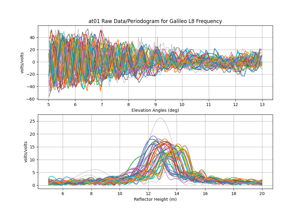
Now about RINEX L8 … also known as E5. This is one of the new Galileo signals. Despite the fact that it is near the frequencies of the other L5 signals, it is not the same. You can see that it in the multipath envelope work of Simsky et al. shown below.

Most of you will not be familiar with multipath envelopes - but for our purposes, we want those envelopes to be big - cause more multipath, better GNSS-IR. First thing, multipath delay shown on the x-axis is NOT the reflector height (RH). it is 2RHsin(elevation angle). So even a pretty tall RH will not be obstructed by the new Galileo codes except for E5.
This is E5a

This is E5. Note that instead of nice clean peaks, it is spread out. You can also see that the E5 retrievals degrades as elevation angle increases, which is exactly what you would expect with the multipath delay increasing with elevation angle. I would just recommend only using this signal for RH < 5 meters. And even then, if you are tracking L8, you probably also have L5, L6, and L7, so there is not a ton gained by also using L8.
What about L1C?
I would be happy to host some results from L1C - please submit a pull request with the needed figures and a description of what you are comparing. I imagine this would require making two snr files - one with L1C and one with L1 C/A. And using only the small subset of satellites that transmit L1C. From what I have seen, it is not much better than L1 C/A - which surprisees me. But I have to imagine it is receiver dependent (some receivers have terrible C/A SNR).
The multipath envelope figure is taken from:
Title: Experimental Results for the Multipath Performance of Galileo Signals Transmitted by GIOVE-A Satellite
Authors: Andrew Simsky,David Mertens,Jean-Marie Sleewaegen, Martin Hollreiser, and Massimo Crisci
International Journal of Navigation and Observation Volume 2008, DOI 10.1155/2008/416380