Files, Formats, Frequencies
Environment Variables
You need three environment variables to run this code: REFL_CODE, ORBITS, and EXE. If you are using the jupyter notebooks or the docker, they are defined for you.
If you are working with pypi or github clone install, you must define them EVERY TIME YOU USE THE CODE. This is most easily done by setting them in your setup script, which on my machine is called .bashrc.
If you are working with the docker, these should all be set up for you. But knowing that they exist can be helpful in looking for files, etc.
How do I collect my own GNSS data?
We do not have instructions in this software package for how you can operate your own receiver for GNSS-IR. Currently we need you to save your observation data as Rinex 2.11, Rinex 3, or NMEA formats (see below). At a minimum you must save the SNR data; we strongly urge you to track/save modern GPS signals, whicha are L2C and L5. If you have multi-GNSS capabilities, we strongly encourage you to use them. And never use an elevation mask on your receiver. They are completely unncessary for positioning (which allows masking to be done at the software level) and are extremely harmful to GNSS-IR.
Where should I store station coordinates?
The software comes with a long list (almost 20,000) of station coordinates taken from the University of Nevada Reno. If you are analyzing data from any of those stations, you should not have to enter any coordinates (Note: you can use query_unr to see if your station is included in the UNR database).
If you are analyzing your own data, eventually you will need to tell the software where your stations are. This location does not have to be super precise, within a few meters is perfectly acceptable, as it is primarily used for the refraction correction. The better your site coordinates, the better your reflection zone maps would be, however. Previously you input this information (latitude, longitude, and ellipsoidal height) when you set your analysis strategy in gnssir_input.
As of version 3.6.4, there is now another option. If you create a plain txt file with the name llh_local.txt and store it in the $REFL_CODE/input directory, the code will use this as your a priori station coordinates. The format of this file for each line should have four entries with spaces between them. These entries are the four character station name, the latitude, the longitude, and ellipsoidal height. The units of the last four are degrees, degrees, and meters. Example for a station called xxxx:
xxxx 39.949492 -105.194266 1728.856
You can add comment lines to the file with a percent sign.
This file is read in the query_coordinate_file function found in gps.py. The local coordinate
file is read by nmea2snr. This means you no longer have to enter station coordinates on
the command line when using that code.
How do I analyze my own GNSS data?
To analyze your own GNSS data you must comply with the software expectations for how the files should be named. The naming conventions for GNSS observation files are given in the next section. You are always better off to use lowercase for Rinex 2.11. For RINEX 3 we follow the convention of the GNSS archives, where the first part is upper case and the stem is lower.
If you are working with the docker, I have made some notes in the docker install section that might be helpful to you about where to store your files.
If you are working with git clone or pypi install, you should be able to have the RINEX files in the directory you are currently working in. Or you should put them in the rinex directory as defined below in the Where Files are Stored section, i.e. $REFL_CODE/YYYY/rinex/abcd where abcd is the station name.
Examples are given in the rinex2snr code.
Documentation can always be improved, so if you would like to add more examples or find the
current documentation confusing, please submit a pull request.
If you don’t know how to read the documentation, I suggest you try typing rinex2snr -h. You will
notice that there is an option called nolook. You have to set this to True.
Example rinex2snr p041 2025 191 -nolook T will look on your coputer for a RINEX 2.11 file
called p0411910.25o. It might look for the Hatanaka compressed file too - I can’t remember.
You are telling the code not to look for the data at an archive. Perhaps that is not the best name for an option, but that is what it is. If you don’t say -nolook T, it will think you want a file in a global GNSS archive and well, it won’t find it if you have the only copy of your data.
If you are using the gnssrefl notebooks, unfortunately no notebook was developed by Earthscope for this option. I am unable to provide you with any assistance. If you would like to share such a notebook as a PR, that would be great.
If you have questions about converting NMEA files, the best I can offer is that you read
the next section on that specific format. The command is nmea2snr.
Many file conversion programs produce orbit files as well as observation files. These orbit files are unnecessary in this software package. The code is set up to find the appropriate orbit files for you.
GPS/GNSS Observation Data Formats
Please keep in mind that there are multiple issues here:
Are your observation files stored in what gnssrefl considers to be a compliant format?
Are your observation files properly named?
Are your observation files stored where the code expects to find them?
Do your observation files include the data we need for GNSS-IR (the SNR observables)
Did you compress you file in some way - and does gnssrefl recognize this kind of compression? (Hatanaka, gzip, Z, etc etc)
Unfortunately all of these issues come into play, and it can be confusing to figure out where the problem is. We have tried as best we can to make screen output that will help you with your problem.
Input observation formats: the code only recognizes RINEX 2.11, RINEX 3 and NMEA input files.
RINEX 2.11
We strongly prefer that you use lower case filenames. I cannot promise you that the code will find files that are stored in uppercase. Lowercase filenames are the standard at global archives. They must have SNR data in them (S1, S2, etc) and have the receiver coordinates in the header. The files should follow these naming rules:
all lowercase
station name (4 characters) followed by day of year (3 characters) then 0.yyo where yy is the two character year.
Example: algo0500.21o where station name is algo on day of year 50 from the year 2021
It is also standard to use the Hatanaka files. Instead of ending in an o the Hatanaka files end in a d.
Example filename : onsa0500.22d
We also generally allow two kinds of compression, unix compression and gzip:
Unix compression example filename : onsa0500.22d.Z
gzip example filename : onsa0500.22o.gz
We do not make any effort to find files with the zip ending. If your files have this ending, you must unzip them before running gnssrefl.
RINEX 3
While we support RINEX 3 files, we do not read the RINEX 3
file itself - we rely on the gfzrnx
utility developed by Thomas Nischan at GFZ to translate from RINEX 3+ to RINEX 2.11
If you have RINEX 3 files, they should be all upper case (except for the extension rnx or crx).
Example filename: ONSA00SWE_R_20213050000_01D_30S_MO.rnx
station name (9 characters where the last 3 characters are the country), underscore
capital R or capital S , with underscore on either side
four character year
three character day of year
four zeroes, underscore,
01D, underscore
ssS, underscore, M0.
followed by rnx (crx if it is Hatanaka format). Note: these are lowercase
01D means it is one day. Some of the other parts of the very long station file name are no
doubt useful, but they are not recognized by this code. By convention, these files may be
gzipped but not unix compressed. If you want a
generic translation program, you can try rinex3_rinex2.
It has the requirement that you input the input and output RINEX file names.
For a few archives, we allow 1 sample per second files. Following the protocol of the IGS, these files are unfortunately 15 minutes long, which means you have to download 96 of them. UNAVCO/Earthscope is much more sensible about providing 1 sample per second files, and returns a single file, at least for the RINEX 2.11 format.
If you want the code to be able to find those highrate files, you must tell the code you want to use the -rate high files and provide -samplerate 1. Why two inputs? Because the -rate high option tells the code to look in a particular folder. The samplerate is related to the name of the file itself.
Recently the IGS and its sister archives have started making a single tar file of the 96 daily files after six months. gnssrefl now allows access to these older data from CDDIS and BKG.
Please see the rinex2snr documentation page for more examples.
NMEA
NMEA formats can be translated to SNR using nmea2snr.
Inputs are similar to that used by rinex2snr: the 4char station name, the year, and day of year.
NMEA files are assumed to be stored as:
$REFL_CODE + /nmea/ABCD/2021/ABCD0030.21.A
for station ABCD in year 2021 and day of year 3.
NMEA files may be gzipped.
This is different than the file structure we used for RINEX files and is entirely due to the wishes of the people that contributed this code. If you would like the code to also allow a traditional folder location (\(REFL_CODE/2021/nmea/abcd or \)REFL_CODE/2021/nmea/ABCD), I am fine with that. I ask that you please submit a pull request.
Additional information about nmea2snr is in the code.
ORBITS
We have tried our best to make the orbit files relatively invisible to users. But for the sake of completeness, we are either using broadcast navigation files in the RINEX 2.11 format or precise orbits in the sp3 format. If you have nav files for your station, we recommend you delete them. They are not useful in this code.
The main things you need to know:
if your files only have GPS data in them, there is no need to use multi-GNSS SP3 files. Flag -nav T
if your files are multi-GNSS, the best option is gnss, which are final orbits. This is complicated for older data. Those files are reliably available from 2023. And they cover the four main constellations.
My current default is rapid GNSS - but that does not always have Beidou in it.we also have ultra-orbit options, which are appropriate for real-time users. I cannot keep track of what ultra products are working. You can try ultra, wum, and wum2. The first is from GFZ and the latter two are from Wuhan. The second file comes from Wuhan directly while the first (I believe) comes from the one stored at CDDIS.
EXECUTABLES
There are two key executables: CRX2RNX and gfzrnx. For notebook and docker users, these
are installed for you. pypi/github users must install them. The utility installexe
should take care of this. They are stored in the directory defined by the EXE environment variable.
We used to support the use of teqc but as Earthscope no longer provides technical support for it,
we have mostly eliminated it.
Where Files are Stored
File structure for station abcd in the year YYYY (last two characters YY), doy DDD:
REFL_CODE/input/abcd/abcd.json - instructions for gnssir analysis, refraction files
REFL_CODE/YYYY/snr/abcd/abcdDDD0.YY.snr66 - SNR files
REFL_CODE/YYYY/rinex/abcd/ - RINEX files of various flavors can be stored here
REFL_CODE/YYYY/results/abcd/DDD.txt Lomb Scargle analysis goes here
REFL_CODE/YYYY/phase/abcd/DDD.txt phase analysis
REFL_CODE/Files/ - various output files and plots will be placed here. For water levels, everything is stored with an additional folder with the station name
ORBITS/YYYY/nav/autoDDD0.YYn - GPS broadcast orbit file
ORBITS/YYYY/sp3/ - sp3 files of orbits - these use names from the archives.
The RINEX files downloaded from archives are not stored by this code. Or at least not deliberately. If they are being translated, they are deleted.
If translating your own files, you should take care to not keep your only copy in your default directory. If they are stored in $REFL_CODE/YYYY/rinex/abcd you will be fine.
You do not need precise orbits to do GNSS-IR. We only use them as a convenience.
Generally we use multi-GNSS sp3 files. See the rinex2snr documentation for more details on
the orbits you can use.
Some of the utilities and environmental products code store files in REFL_CODE/Files The locations of these files are always provided in the screen output.
The inputs to gnssir are generally stored in the REFL_CODE/input folder.
This primarily means the Lomb Scargle data analysis inputs, i.e.
the “json” files, e.g. p041.json for station p041.
It also includes the refraction file (p041_refr.txt) that is
created automatically. This calculation
requires a set of parameters stored in a “pickle” format, gpt_1wA.pickle.
This file should be automatically stored for you.
The SNR data format
Reminder: UTC does not exist in our world. Everything should be GPS time, which is UTC without leap seconds.
The snr options are mostly based on the need to remove the “direct” signal. This is not related to a specific site mask and that is why the most frequently used options (99 and 66) have a maximum elevation angle of 30 degrees. The azimuth-specific mask is decided later when you run gnssir. The SNR choices are:
66 is elevation angles less than 30 degrees (this is the default)
99 is elevation angles of 5-30 degrees
88 is all data
50 is elevation angles less than 10 degrees (good for very tall sites, high-rate applications)
66,99, etc are not good names for files. And for this I apologize. It is too late to change them now. The SNR files are not self-documenting (i.e. there is no header) and for that I also apologize.
The columns in the SNR data are defined as:
Satellite number (remember 100 is added for Glonass, 200 for Galileo, 300 for Beidou)
Elevation angle, degrees
Azimuth angle, degrees
Seconds of the day, GPS time
elevation angle rate of change, degrees/sec.
S6 SNR on L6
S1 SNR on L1
S2 SNR on L2
S5 SNR on L5
S7 SNR on L7
S8 SNR on L8
The unit for all SNR data is dB-Hz. In some cases these frequencies come from RINEX conventions. The constellation people themselves do not use them. See below for more information.
I do not currently use SBAS signals, but they would be easy to add if someone wants to make a PR. I suggest 400 be added to such signals and someone needs to define the various organizations that run SBAS satellites.
GNSS frequencies
gnssrefl uses numbers for the frequencies that are defined in the RINEX files:
1,2,20, and 5 are GPS L1, L2, L2C, and L5
101,102 are Glonass L1 and L2
201, 205, 206, 207, 208 are Galileo frequencies, which are set as 1575.420, 1176.450, 1278.70, 1207.140, 1191.795 MHz
302, 306, 307 are Beidou frequencies, defined as 1561.098, 1207.14, 1268.52 MHz
This means that if you want the Beidou frequency data from 1561.098, you need to look in the “L2” column. If you want the 1278.70 Galileo frequency, you need to look in the “L6” column.
Additional files
EGM96geoidDATA.mat is stored in REFL_CODE/Files
station_pos2024.db is stored in REFL_CODE/Files. This is an updated compilation of station coordinates from Nevada Reno.
gpt_1wA.pickle is stored in REFL_CODE/input. This file is used in the refraction correction.
GPSorbits_21sep17.txt, GALILEOorbits_21sep17.txt, etc are stored in REFL_CODE/Files. These are used for refl_zones and max_resolve_RH
leapsecond file, ONLY for nmea2snr, REFL_CODE/Files/leapseconds.txt
Some comments about signals
GPS L2C
Why do I like L2C? What’s not to like? It is a modern civilian code without high chipping rate. That civilian part matters because it means the receiver knows the code and thus retrievals are far better than a receiver having to do extra processing to extract the signal. Here is an example of a receiver that is tracking both L2P and L2C. Originally installed for the Plate Boundary Observatory, it is a Trimble. The archive (unavco) chose to provide only L2P in the 15 second default RINEX file. However, it does have the L2C data in the 1 second files. So that is how I am able to make this comparison. P038 is a very very very flat site.
Here are the L2P retrievals:

Now look at the L2C retrievals.
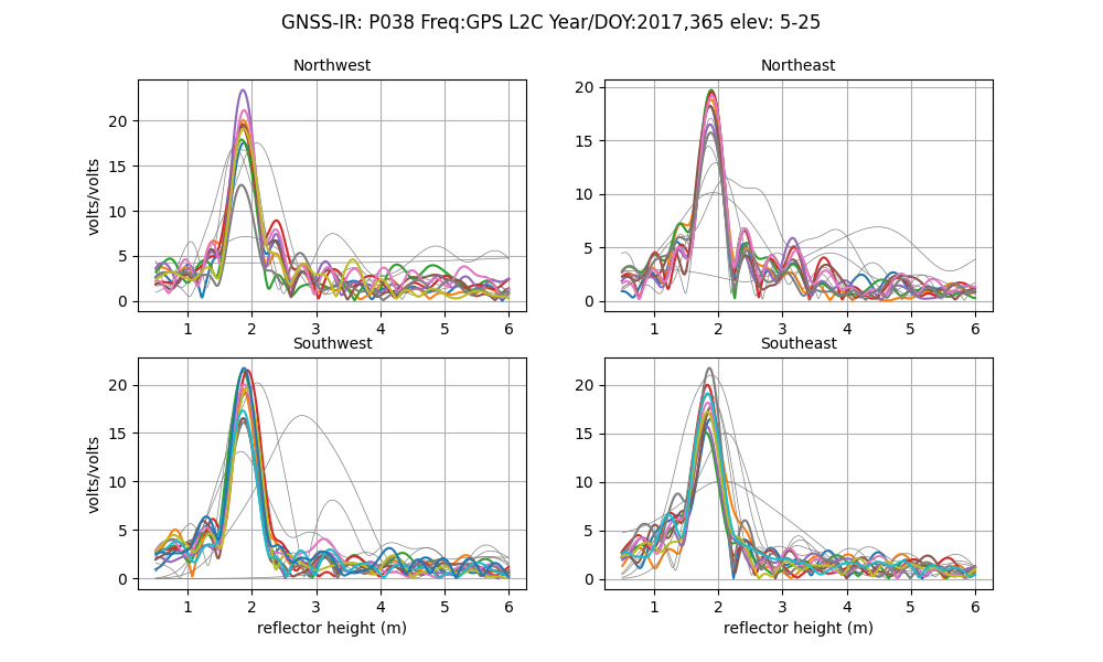
If you were trying to find a periodic signal, which one would you want to use?
To further confuse things, when the receiver was updated to a Septentrio, unavco began providing L2C data in the default 15 second files. This is a good thing - but it is confusing to people that won’t know why the signal quality improved overnight.
L2C is easy to extract from RINEX 3 files - and that is what is done by rinex2snr. However,
I do not make the same restriction for RINEX 2.11 files. In principle I could, but for now, I translate
all L2 signals in a RINEX 2.11 file. When you subsequently chose L2C (frequency 20) in gnssir, you will
be given results for all GPS satellites that could be L2C. The list of L2C transmitting satellites is found
in the gps.py library.
GPS L5
Another great signal. I love it. It does have a high chipping rate, which is relevant (i.e. bad) for reflectometry from very tall sites.
Aliasing
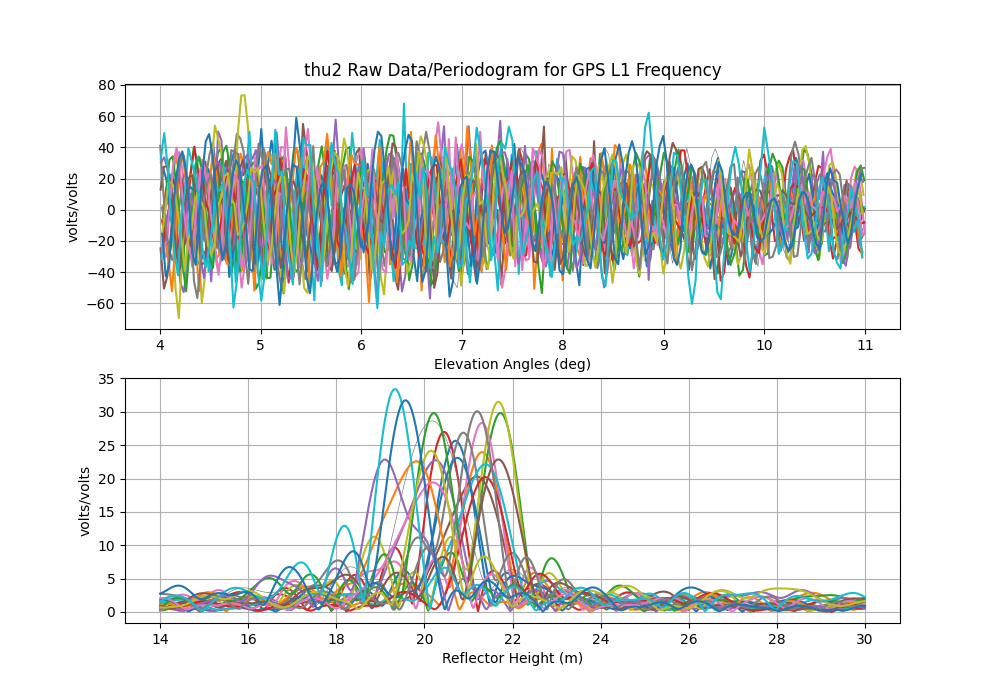
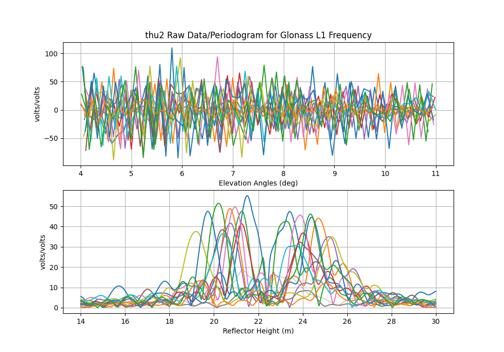
While it will show up in GPS results too - there seems to be a particularly bad problem with Glonass L1. I used an example from Thule. The RH is significant - ~20 meters. So you absolutely have to have at least 15 sec at the site or you violate the Nyquist. Personally I prefer to use 5 sec - which means I have to download 1 sec and decimate. This is extremely annoying because of how long it takes to ftp those files to my local machine. Let’s look at L1 solutions using a 5 second file - but where I invoke the -dec option for gnssir. That way I can see the impact of the sampling. I also using the -plt T option.
This is 5 second GPS L1.
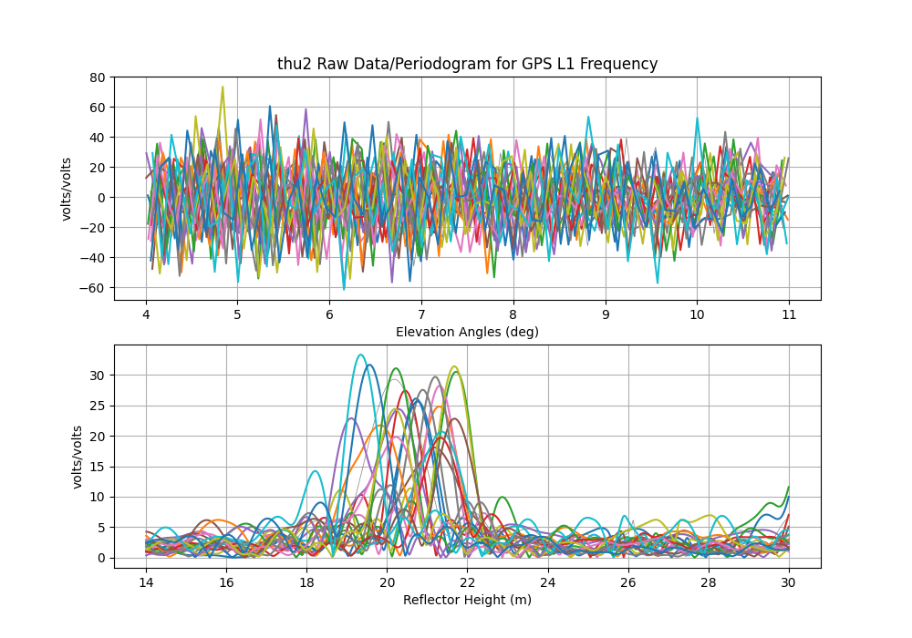
This is 15 second GPS L1. You see some funny stuff at 30 meters, and yes, the periodograms are noisier. But nothing insane.
Now do 5 second Glonass L1
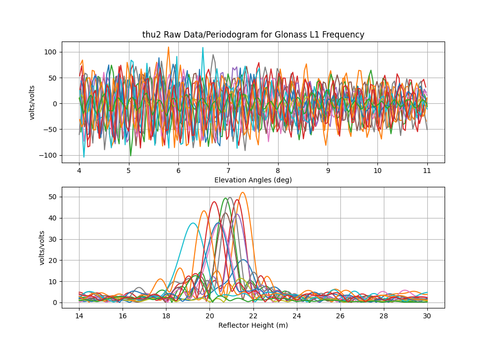
Contrast with the Glonass L1 results using 15 sec decimation! So yeah, aliasing is a problem.
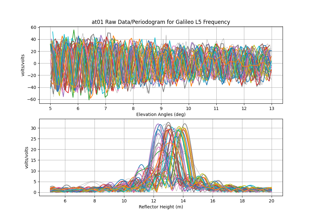
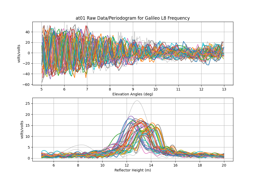
E5
Now about RINEX L8 … also known as E5. This is one of the new Galileo signals. Despite the fact that it is near the frequencies of the other L5 signals, it is not the same. You can see that it in the multipath envelope work of Simsky et al. shown below.
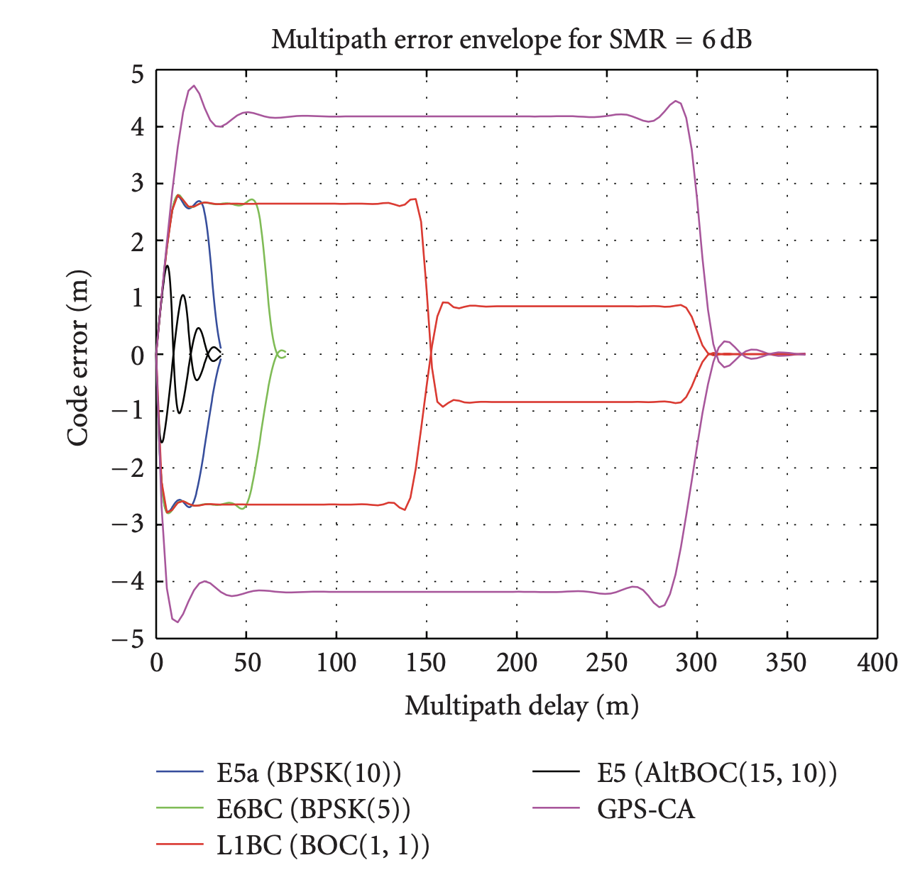
Most of you will not be familiar with multipath envelopes - but for our purposes, we want those envelopes to be big - cause more multipath, better GNSS-IR. First thing, multipath delay shown on the x-axis is NOT the reflector height (RH). it is 2RHsin(elevation angle). So even a pretty tall RH will not be obstructed by the new Galileo codes except for E5.
This is E5a
This is E5. Note that instead of nice clean peaks, it is spread out. You can also see that the E5 retrievals degrades as elevation angle increases, which is exactly what you would expect with the multipath delay increasing with elevation angle. I would just recommend only using this signal for RH < 5 meters. And even then, if you are tracking L8, you probably also have L5, L6, and L7, so there is not a ton gained by also using L8.
L1C
The Trimble Alloy receiver at Mitchell (MCHL) in Australia records both legacy L1 and modern L1C signals, which are available in the daily RINEX 3 files. RINEX 3 names the legacy signal “L1C” and the modern signal “L1X” (the SNR observables are thus “S1C” and “S1X”). RINEX 2 does not support both signals simultaneously, so two separate files must be created. For example, using gfzrnx:
gfzrnx -finp FILE.rnx -fout OUTPUT_L1C.rnx -ot S1C -vo 2
gfzrnx -finp FILE.rnx -fout OUTPUT_L1X.rnx -ot S1X -vo 2
These files can be renamed and processed using rinex2snr/gnssir. First, the legacy results for MCHL 2023/day 1:

And the modern signal results, showing marginally higher peaks in the LSP:

There is less data for L1X as the modern signal is only broadcast by Block III satellites, of which there are currently only 10 (in Feb 2025).
The multipath envelope figure is taken from:
Title: Experimental Results for the Multipath Performance of Galileo Signals Transmitted by GIOVE-A Satellite
Authors: Andrew Simsky,David Mertens,Jean-Marie Sleewaegen, Martin Hollreiser, and Massimo Crisci
International Journal of Navigation and Observation Volume 2008, DOI 10.1155/2008/416380