Estimating Reflector Heights
gnssir_input
A full listing of the possible inputs and examples for gnssir_input can be found here.
Your first task is to define your analysis strategy. If the station location is in our database:
gnssir_input p101
If you have your own site, you should use -lat, -lon, -height as inputs.
If you happen to have the Cartesian coordinates (in meters), you can
set -xyz True and input those instead.
The json file of instructions will be stored in $REFL_CODE/input/p101/p101.json.
The default azimuth inputs are from 0 to 360 degrees. You can set your preferred azimuth regions using -azlist2. Previously you were required to use multiple azimuth regions, none of which could be larger than 100 degrees. That is no longer required. However, if you do need multiple distinct regions, that is allowed, e.g.
gnssir_input p101 -azlist2 0 90 180 270
If you wanted all southern quadrants, since these are contiguous, you just need to give the starting and ending azimuth.
gnssir_input p101 -azlist2 90 270
You should also set the prefrred reflector height region (h1 and h2) and elevation angle mask (e1 and e2). Note: the reflector height region should not be too small, as it is also used to set the region for your periodogram. If you use tiny RH constraints, your periodogram will not make any sense and your work will fail the quality control metrics.
gnssir
gnssir estimates reflector heights. It assumes you have made SNR files and defined an analysis strategy.
The minimum inputs are the station name, year, and doy.
gnssir p041 2020 150
Where would the code store the files for this example?
json instructions are stored in $REFL_CODE/input/p041/p041.json
SNR files are stored in $REFL_CODE/2020/snr/p041
Reflector Height (RH) results are stored in $REFL_CODE/2020/results/p041/150.txt
For more information about the decisions made in gnssir, set -screenstats T
For plots, set -plt to T or True.
If you want to try different strategies, use multiple json files with the -extension input. Then use the same -extension command
in gnssir.
This is a snippet of what the result file would look like
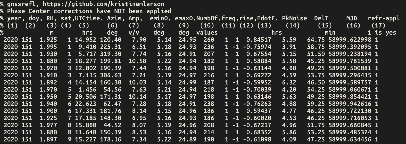
Note that the names of the columns (and units) are provided:
Amp is the amplitude of the most significant peak in the periodogram (i.e. the amplitude for the RH you estimated).
DelT is how long a given rising or setting satellite arc was, in minutes.
emin0 and emax0 are the min and max observed elevation angles in the arc.
rise/set tells you whether the satellite arc was rising (1) or setting (-1)
Azim is the average azimuth angle of the satellite arc
sat and freq are as defined in this document
MJD is modified julian date
PkNoise is the peak to noise ratio of the periodogram values
last column is currently set to tell you whether the refraction correction has been applied
EdotF is used in the RHdot correction needed for dynamic sea level sites. The units are hours/rad. When multiplied by RHdot (meters/hour), you will get a correction in units of meters. For further information, see the
subdailycode.ediff QC metric
For programmatic access to individual arcs (e.g. for custom plotting or analysis), see Extracting Satellite Arcs (Python API).
Warning: We try to enforce homogenous track lengths by using a quality control factor called ediff. Its
default value is 2 degrees, which means your arc should be within 2 degrees of the requested elevation angle inputs.
So if you ask for 5 and 25 degrees, your arcs should at least be from 7 to 23 degrees. To tell
gnssir you want to allow smaller arcs, just set ediff to a much larger value.