quickLook
quickLook is meant to provide the user with a visual sense of the data
at a given site. It has stored defaults that work for stations with reflectors that are
lower than 8 meters or so. You can change those defaults on the command line.
Example from Boulder
quickLook p041 2020 132
That command will produce this periodogram summary :
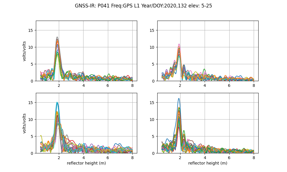
By default, these are L1 data only. Note that the x-axis does not go beyond 6 meters. This is because you have used the defaults. Furthermore, note that results on the x-axis begin at 0.5 meters. Since you are not able to resolve very small reflector heights with this method, this region is not allowed. These periodograms give you a sense of whether there is a planar reflector below your antenna. The fact that the peaks in the periodograms bunch up around 2 meters means that at this site the antenna phase center is ~ 2 meters above the ground. The colors change as you try different satellites. If the data are plotted in gray that means you have a failed reflection. The quadrants are Northwest, Northeast and so on.
quickLook also provides a summary of various quality control metrics:
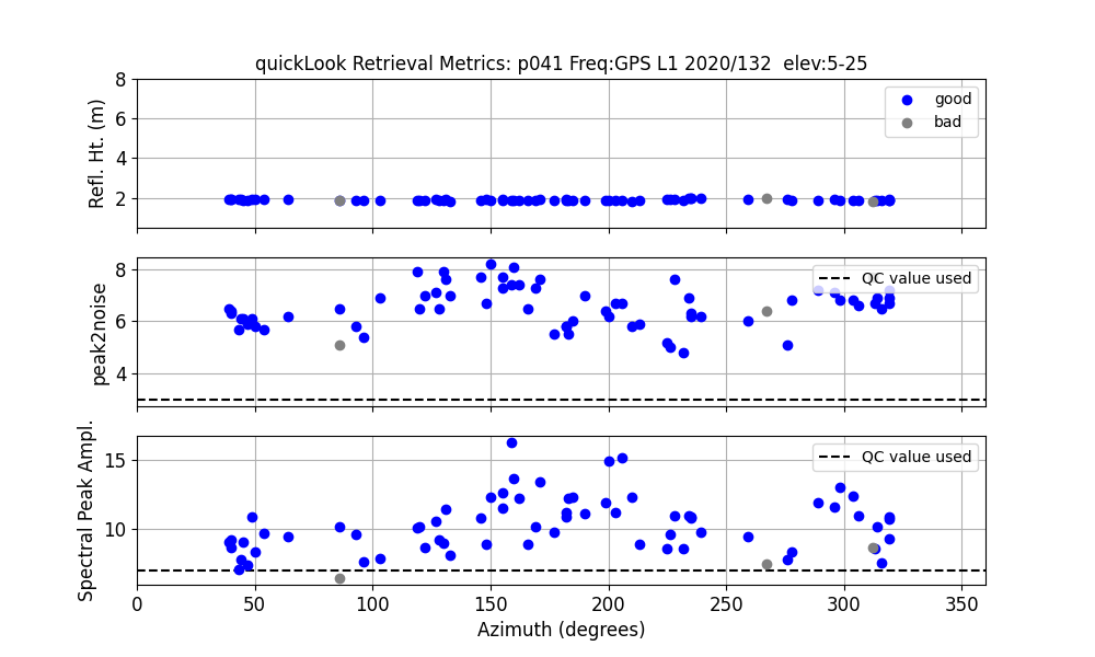
The top plot shows the sucessful RH retrievals in blue and unsuccessful RH retrievals in gray. In the center panel are the peak to noise ratios. The last plot is the amplitude of the spectral peak. The dashed lines show you what QC metrics quickLook was using. You can control/change these on the command line.
If you want to look at L2C data you just change the frequency on the command line. L2C is designated by frequency 20:
quickLook p041 2020 132 -fr 20
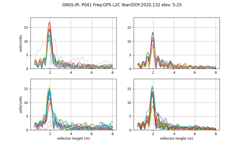
L2C results are always superior to L1 results. They are also superior to L2P data. If you have any influence over a GNSS site, please ask the station operators to track modern GPS signals such as L2C and L5 and to include it in the archived RINEX file.
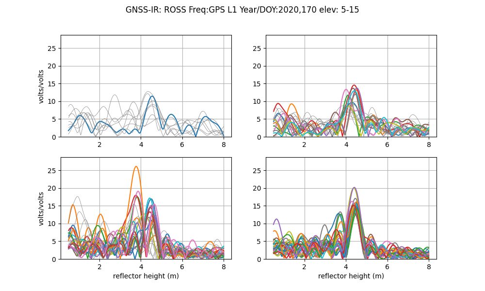
Example for Lake Superior
quickLook ross 2020 170 -e1 5 -e2 15
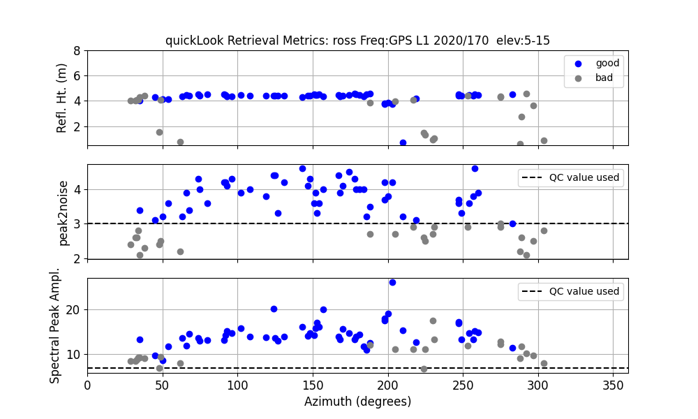
The good RH estimates (in blue in the top panel) are telling us that we were right when we assessed reflection zones using 4 meters. We can also see that the best retrievals are in the southeast quadrant (azimuths 90-180 degrees). This is further emphasized in the next panel, that shows the actual periodograms.
Example for a site on an ice sheet
In addition to the peak2noise and required amplitude (ampl) QC metrics, there is a
couple more QC metrics that are hardwired. One is the length of time
allowed for an arc - this can be a problem when you have an arc that crosses midnite;
since the gnssrefl code works on elevation angle, it will combine part of
the arc from the beginning of the day and the rest
from the end of the day. This is not sensible - and it will reject this arc
nominally for being far too long. Really it is rejecting it because it is non-physical.
The Python API offers a buffer_hours option that solves this — see
Midnight-Crossing Arcs.
The code tries to find all eligible arcs between elevation angles e1 (emin) and e2 (emax).
Why? In my experience you don’t want to use an arc that only goes from 5-10 degrees if you
are trying to use all arcs between 5 and 25 degrees. The same is true for small
arcs at higher elevation angles (20-25). However, you don’t want to be
too strict, so there is a QC setting called ediff.
The default is 2 degrees. For a given emin and emax for your arcs, quickLook
will allow you to use arcs that are at least within this amount in degrees, i.e.
(emin +ediff) and (emax - ediff). The net result of this QC setting
default is to make it less likely you will try to use a very short arc.
Although this cannot be changed for quickLook, you
can change it in gnssir in your json file. If you want gnssir to use
everything, just make ediff very large.
Warning: quickLook calculates the minimum observed elevation
angle in your file and prints that to the screen so you know
what it is. It also uses that as your emin
value (e1) if the default is smaller. It does this so you don’t see all arcs as rejected.
Let’s say your file had a receiver-imposed elevation cutoff
of 10 degrrees. The default minimum elevation angle in quickLook is 5 degrees.
With the default ediff value of 2, not a single arc would reach the minimum
required value of 7 (5 + 2); everything
would be rejected. quickLook instead sees that
you have a receiver-imposed minimum of 10 and would substitute that for the default emin.
gnssir does not do this because at that point you
are supposed to have chosen a strategy, which is stored in the json file.
quickLook -screenstats True provides more information to the screen
about why arcs have been rejected.