Niwot Ridge, Colorado, USA
nwot
Status: The equipment has been installed and removed multiple times. As of spring 2020, it is no longer available.
Station name: nwot
Location: Niwot Ridge LTER
Archive: UNAVCO
Ellipsoidal Coordinates:
Latitude: 40.05539
Longitude: -105.59053
Height(m): 3522.729
Data Summary
Station nwot was originally installed/designed by Jim Normandeau (UNAVCO) to support GPS reflections research by Kristine Larson, Eric Small, Ethan Gutmann, Felipe Nievinski, and Mark Williams at the University of Colorado.
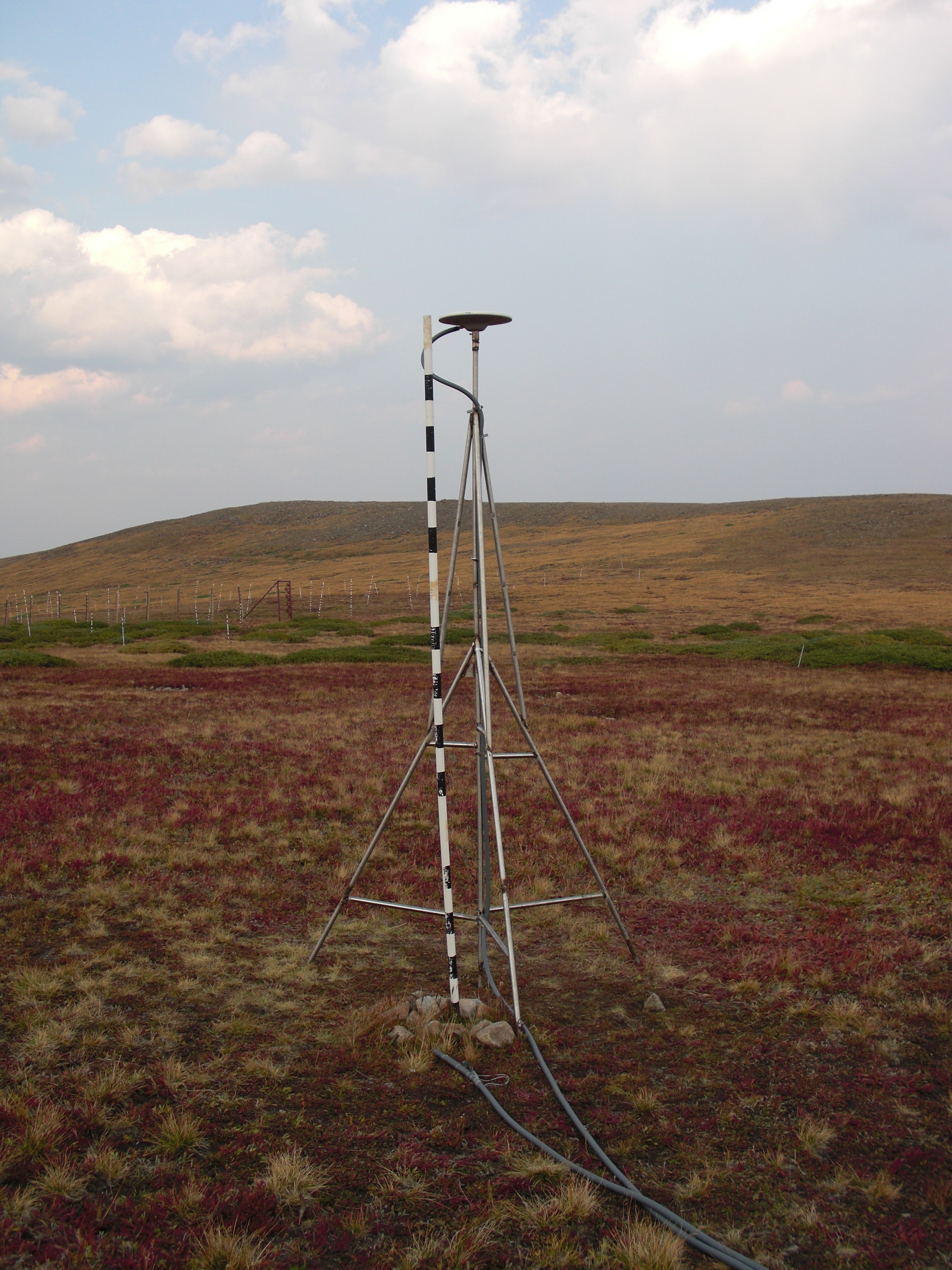
nwot was deliberately made to be taller than the typical geodetic antenna so that it would never be buried by snow. It is approximately 3 meters above the bare soil surface. Because it was installed to support testing GPS reflections, nwot has always tracked L2C. nwot was also part of PBO H2O.
The site has not generally been used by geodesists and there is very little useful information about when data are available at either UNAVCO or Nevada Reno (i.e. no time series). After the original receiver failed in spring 2015, a new receiver was installed sometime in 2017 by Mark Raleigh (now at the University of Oregon). The receiver failed in 2020 and was removed two years later. We will focus here on the data between 2009-2015.
Make a SNR File and run quickLook
We will start by making a single SNR file. Here there are two options. The main archive for this dataset only provides the high-quality L2C data in the highrate (1-sec) area. We do not need this sample rate for a GPS site that is three meters tall. To speed things up, we strongly encourage you to use the “special” archive option. Here the 1-sec data have been decimated to 15 seconds:
rinex2snr nwot 2014 270 -archive special
If for any reason this command does not work, please use the direct command:
rinex2snr nwot 2014 270 -archive unavco -rate high -dec 15
Both L1 and L2C signals can be used at this site, though the L2C data are far superior in quality to the L1 data. Use this quickLook command to get a sense of the quality of the reflector height (RH) retrievals. First L1:
quickLook nwot 2014 270
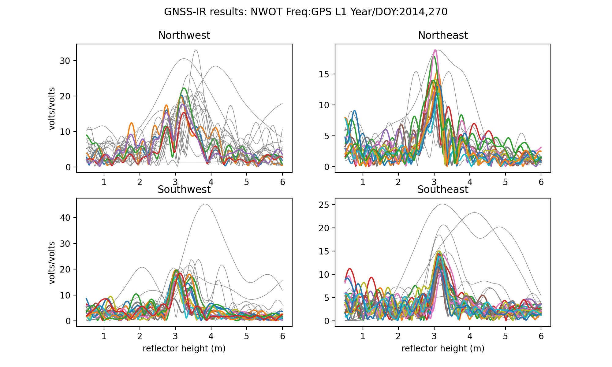
These periodograms are a bit ratty in the low RH area. There are nice strong peaks in the southern quadrants. Now try L2:
quickLook nwot 2014 270 -fr 2

This plot will have both L2C and non-L2C. But it is easy to see why I don’t use non-L2C. They are the failed tracks in the gray that I have circled.
Make multiple years of SNR files
We are going to look at the data from installation (Fall 2009) through Spring 2015 :
rinex2snr nwot 2009 240 -year_end 2015 -doy_end 120 -archive special
Run gnssir for multiple years
Save your gnssir analysis strategy:
gnssir_input nwot -e1 7 -e2 25 -peak2noise 3.2 -azlist2 90 270 -frlist 1 20
I have opted to only use the southern quadrants (azimuths 90 through 270). Note that since L5 was not tracked at this site, only 1 and 20 are set in the frequency list. I am using a minimum elevation angle of 7 degrees because this particular receiver had a limit on the number of satellites it could track. In some cases this meant the low elevation data are not available and that triggers QC restrictions.
Once you have a strategy set up, run gnssir for the years 2009-2015:
gnssir nwot 2009 1 -doy_end 366 -year_end 2015
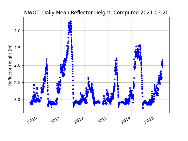
Compute daily average RH values
Use the daily_avg utility to compute RH for each day. A median filter of 0.25 meter is used
to eliminate large outliers and a minimum number of tracks is set to 10. This is relatively
low because of the small number of L2C transmitting satellites in the early years of
the dataset. The year inputs here are optional.
daily_avg nwot 0.25 10 -year1 2009 -year2 2015
produces this plot:
and this file. The files will be stored in the $REFL_CODE/Files directory.
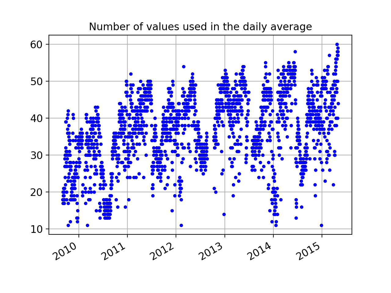
You are also shown how many successful retrievals there are each day so that you can change that input if you prefer:
Validation
We installed the GPS site at Niwot Ridge because there was a long-standing experiment for measuring snow depth (and snow water equivalent). We therefore have a way to assess accuracy. We download the in situ data from
the Niwot Ridge facility. We will compare to pole 16, which is shown in the photograph above. The relevant Niwot Ridge csv file is provided here:
in situ data from the Niwot Ridge LTER
If the daily average RH file created above is stored in the same directory as the Niwot Ridge in situ datafile, you can use this python script to visually compare them:
python nwot_usecase.py
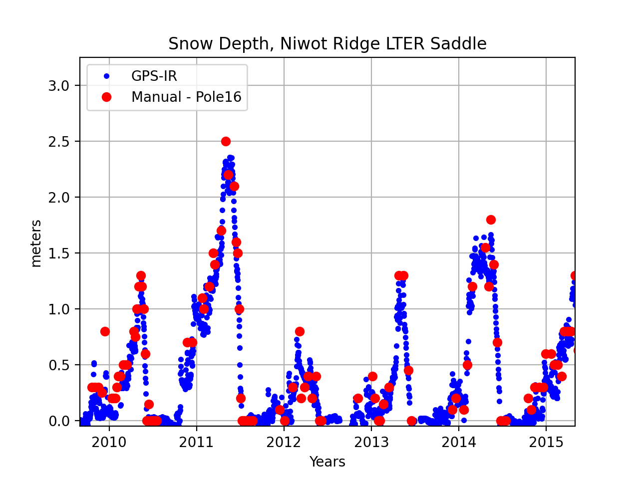
We have used the data from the fall to set the bare soil value for reflector height (RH_baresoil). Snow depth is then defined as:
snow depth = RH_baresoil - RH
Please keep in mind that the pole measurements are not representative of the same footprint as the GPS measurements. The latter cover an average over a much larger region.
snowdepth utility
After this use case was first written the snowdepth module was developed.
It requires an input of station name and (North American) water year. It requires that you
run daily_avg prior to running snowdepth OR you input that module’s
required parameters on the command line. Assuming I have run daily_avg:
snowdepth nwot 2014
produces:

and a plain text list of daily snow accumulation values. The bare soil dates are configurable - here I used the defaults (which are to use September 1-30).
Publications about nwot
Please see the following for a lengthier discussion of this site:
Nievinski, F.G., Ph.D. Dissertation, University of Colorado, 2013